

Conconi Reef is located in Navy Channel between North Pender and Mayne Island... closer to Mayne. Occasionally we see some pretty large Navy ships come cruising by... or the red Coast Guard vessels..

or tug boats pulling a log boom.

We have learned to use this beacon on the reef to tell us if the tide is in... or out... depending if we see lots of rock or none at all.

This pre-dawn photo shows several cargo freighters moored in Navy Channel. I will never forget the stormy night that one of these vessels dragged anchor and came aground on Conconi Reef.

The Coast Guard came to the rescue and light up the night... calling in several tug boats that eventually pried it off the rocks. The Hebei Lion cargo ship was an absolutely huge freighter... 241 meters long. That is like two and a half football fields long! Thankfully it was not a tanker and there was no pollution and no damage.
This photo is what happens when you try to hand hold a telephoto lens against a hand rail in a windstorm. Thank you Shirley for capturing these memories of that night. I had some equally bad shots that went into the trash.

We were awakened by the bright lights in the middle of the night... and we were not nearly as close to the event and Janine and John Dodds... who told us they feared this ship was going to end up in their living room!

This Parks sign on Navy Channel Road marks the access to Conconi Reef Park. It's a pretty general sign with no individual park identity.

It was the 2014 Mayne Island Hiking and Walking Trail Map that told me the name of this park. I applaud this little brochure and anyone wanting to explore Mayne Island would be well served to pick up one on the ferry... or maybe at Georgina Point Lighthouse. They identify 24 locations on our island to walk or hike, many with great views and lookouts.

A gentle grade path about 100 meters leads to the beach.

From the beach you can see how much of the Conconi Reef shows in low tide. Check out the sea gull sitting on top of the beacon light.

How high does the water usually reach at high tide? I think the white residue line on the ladder side is just above high water.... the splash line.
Looking closer at the foundation I tried to estimate how high it is. Based on the number of rungs on the ladder, which are usually don't exceed 12 inches apart I estimate that height of the foundation is about 7 to maybe 8 feet. I'm guessing that the white residue line is about two feet above the rocks, leaving about 5 feet or so of foundation out of the water.

This picture taken from our deck shows only a hint of the rocks covered by water... not yet to the white residue line... but getting close.

We have yet to see any whales in Navy Channel... but we do see an occasional whale watching boat.

The Victoria Chipper III went speeding by... maybe they just got a hot tip on where the whales were jumping.

One thing for certain, there is always something coming of going in Navy Channel. I didn't realize how much the seagulls enjoy sitting on the beacon light.
.jpg)
The first time we brought our son and family to this beach park the tide was in.
.jpg)
We played on the beach and watched the dogs... chasing balls and digging in the sand.
.jpg)
Our grand daughters soon tired of the beach and took on the challenge of hiking out to the rocks off shore... which was a trick to do and stay dry!

It looks a lot different when you visit here at low tide... there is a lot of green visible.

At first glance I just thought it was sea weed.


Lots of interesting rocks... can you see this frog watching us. Two eyes, a nose... a big grin.


Several rocks looked like concrete aggregate.

I asked Shirley to stand beside this huge aggregate bolder to show the size of it. When we were here at high tide this rock was inaccessible without getting wet.

It's fun to explore for shells... this one has a few hitchhikers.

And these have a lot of hitchhikers.
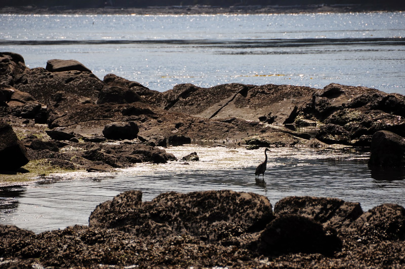
We watched this blue heron for some time... even saw him successfully catch and swallow a fish!

I think this cormorant is looking for his mate... I heard him calling, "Come, I've saved a post for you. Please hurry."

There may be only a small part of the beach with choice sand... but someone spent some enjoyable time making a sand castle.

One of the advantages of coming to Conconi Reef Park is you often have the whole place to yourself... we'll almost to yourself!

We have yet to come to this beach without a visit from the owner of the park... Baxter... woof, woof!

Come on in, the water is fine.

Just across the road is another trail that goes up the hill to an excellent viewpoint of Conconi Reef and Navy Channel.

It starts out pretty gentle... but then it gets a little steeper.


...which is partly true. This section on the way back down was pretty easy. When we got back home I showed her that the hiking guide really did rate this trail as "easy."

We came back another day to do this hike when the tide was up just to show the difference.

It was pretty close to having none of the rocks on the reef above water.
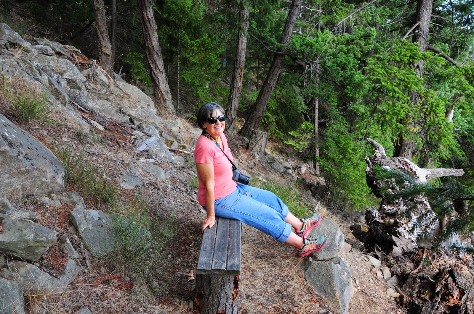
Shirley liked the welcome bench at the viewpoint... it took a while for her to get up the courage to leave.

We enjoyed the views of Navy Channel from here.

What a pleasant outlook on the world from here. While Shirley was busy taking photos, I headed back down. I was interested to eat some blackberries.

There were some ripe blackberries at the entrance to the uphill trail. Can you see me in this picture... I couldn't find me either until Shirley told me where to look. You can see my white hat just to the left of the stump.

By climbing up the hill behind the blackberries I could get to a spot that most people find too difficult to get to.

They were so ripe it was hard to reach them without them falling off. It was a bonus to to pick a half a pail in just a few minutes... nice on the breakfast cereal.
I think that Conconi Park is one of the best kept secrets on Mayne Island. I find it hard to believe it took us about 12 years after moving here to discovered it... and it is so amazing... we love it.
Quote of the Day
"With every drop of water you drink, every breath you take, you're connected to the sea. No matter where on Earth you live." -Sylvia Earle
"There is no life without water...
because without water there is no coffee."
I want to give credit to my wife Shirley Ann for several photos in this blog... more than the night shots... the family shots of our kids on the beach, some of the shells, and me in the blackberry patch. Basically all the best photos are Shirley's... the rest are mine.
These photos are the private property of Sherwin and Shirley Ann Goerlitz. They are not to be copied or used with out our express permission... or you will be prosecuted to the fullest extent of the law. Which is likely nothing more than 39 lashes with a wet noodle.
If you enjoy this blog don't skip the comments box... We live for your comments and are near death.


